How to Get to Seyðisfjörður: Ferry, Road, Air and Ship
Working out how to get to Seydisfjordur comes down to one road, which climbs to 600 metres before it reaches anywhere, and one ferry. The town sits at the end of a 17 km fjord, and it is the only place in Iceland where you can arrive from abroad with your own car. This page covers the four ways in, what each costs in time, and the one variable that decides all of them in winter.
Quick answer
By road it is Route 93 from Egilsstaðir, 27 km over the Fjarðarheiði pass at 600 m, about 25 minutes in summer and closed in winter storms. By sea there are two options: the Smyril Line ferry Norröna from Hirtshals in Denmark by way of the Faroe Islands, running March to October, and cruise calls between May and September. By air the nearest airport is Egilsstaðir, with domestic flights from Reykjavík, and then the same 27 km of road. There is no scheduled bus and no car rental desk in the town.
Key takeaways
- Road: Route 93, 27 km, one pass at 600 m, roughly 25 minutes in good conditions
- Ferry: the Norröna sails Hirtshals to Seyðisfjörður via Tórshavn, about 47 hours from Denmark, March to October
- The Norröna is the only car ferry between Iceland and another country
- Air: Egilsstaðir airport, domestic flights, then 27 km by road
- Cruise: two piers take ships up to about 170 m; anything larger anchors and tenders in
- No bus, no rental desk in town, so onward travel needs a car, a taxi or a booked trip
The Four Ways In
Each one drops you in a different position for what comes next, which matters more here than the journey itself.
| Route | Time | Season | Leaves you with |
|---|---|---|---|
| Route 93 from Egilsstaðir | About 25 minutes | All year, storm closures in winter | Your own vehicle |
| Norröna ferry from Denmark | About 47 hours | March to October | Your own vehicle, straight off the ship |
| Norröna from Tórshavn | 15 to 18 hours | March to October | Your own vehicle |
| Flight to Egilsstaðir plus car | About an hour from Reykjavík, then 25 minutes | All year | A rental collected at the airport |
| Cruise call | 8 to 10 hours ashore | May to September | Your feet, or a booked trip |
By Road
Route 93 and the pass
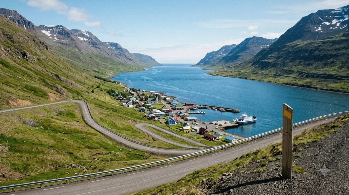
One road leaves the town. Route 93 climbs from sea level to the Fjarðarheiði pass at 600 m and drops to Egilsstaðir and the Ring Road, 27 km away.
In summer it is a scenic half hour, and the descent into the fjord on the way back is the view that ends up on postcards. In winter it closes in storms, sometimes for days, and avalanche closures happen in late winter and spring. Anyone driving it out of season should check the road forecast the morning of the trip rather than the night before.
A tunnel under the pass has been argued about for years. The 2025 transport plan put the Fjarðarheiði bore behind a competing scheme elsewhere in the region and pushed construction past 2040, so the pass is the road for the foreseeable future.
Getting further
Egilsstaðir is the hub. It has the airport, the supermarkets, the fuel, the car rental and the beds, and from there the Ring Road runs in both directions. Vök Baths is 5 km beyond it, Stuðlagil Canyon about an hour up the valley on road 923, and Borgarfjörður Eystri an hour and a quarter north on Route 94.
All of those distances are measured from Egilsstaðir rather than from Seyðisfjörður, which is why every guided trip out of the fjord has 25 minutes of pass built into each direction before it starts.
Distances from the town
Once you are in the fjord, this is the map that matters. Every guided trip is priced against these numbers.
| Destination | Distance | Drive time | Road |
|---|---|---|---|
| Gufufoss waterfall | 3.6 km | 4 minutes | Route 93, up the valley |
| Egilsstaðir | 27.2 km | 25 minutes | Route 93 over the pass |
| Vök Baths | 32.6 km | 32 minutes | Past Egilsstaðir |
| Hafnarhólmi puffin colony | 92.9 km | 84 minutes | Route 94, one more pass |
| Stuðlagil Canyon | 98.8 km | 90 minutes | Road 923 off the Ring Road |
| Reykjavík | About 650 km | A full day | Ring Road, either direction |
Driving it yourself in summer
Route 93 is paved the whole way and needs no special vehicle between May and September. What it does need is your attention on the descent, which is steep enough that coaches take it slowly and there are places where the drop is close to the tarmac.
Fuel is in Egilsstaðir rather than Seyðisfjörður, and the pumps take cards without a cashier. Speed limits are 90 on the open road and drop sharply through the town, and the fines for ignoring them are enforced. Sheep stand in the road all summer and have no plan for avoiding you.
Route 93 over Fjarðarheiði in winter
The 27 km road from Egilsstaðir climbs to about 620 metres and drops into the fjord in hairpins, and it is the variable that decides winter access. Snow closes it several times a season, sometimes for hours.
The local habit is to check road.is before leaving Egilsstaðir rather than before leaving your accommodation, and to expect the road service to prioritise clearing it when the ferry is due. Anyone with a flight out of Egilsstaðir the same day should build in an extra hour rather than assume the pass is open.
By Ferry
The Norröna
Smyril Line runs the Norröna from Hirtshals in Denmark to Seyðisfjörður by way of Tórshavn in the Faroe Islands. The full crossing takes around 47 hours, and the leg from Tórshavn to Iceland is 15 to 18 hours of it. Sailings to Iceland run from March to October, weekly for most of the season with a second departure in high summer.
It is the only car ferry between Iceland and any other country. That single fact explains a good share of the campervans you meet in the east and why a town of 676 people has a terminal at all.
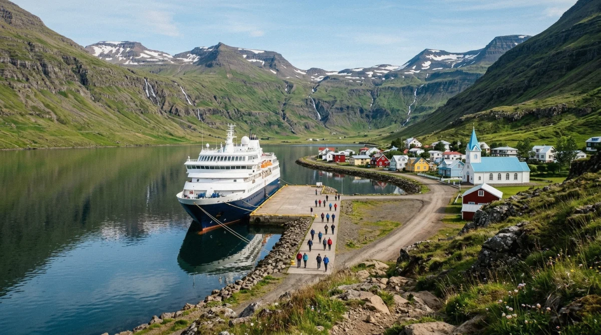
The ship berths at the ferry terminal in the town, on the same water the cruise ships use. On a ferry day there is a second wave of arrivals, most of them driving off towards the pass within the hour.
Whether it is worth it
Two nights at sea against a three-hour flight is a trade you make for the car, not for the crossing. If you want your own vehicle in Iceland for two weeks, the ferry saves you a rental at Icelandic prices and gives you a boot you can fill with food from home.
If you are travelling without a vehicle, fly. The ferry is slower, it costs more than a budget flight, and the North Atlantic in either direction is not always kind.
What arriving by sea actually involves
The Norröna docks in the middle of the village rather than at an industrial terminal, so you step off into the place itself. Vehicles come off first and foot passengers follow, and the whole process is quick by ferry standards because the ship is small and the port is one berth.
Customs checks happen at the quay and are usually brief. What catches people is the schedule around it: the town's cafés and the single supermarket work to ferry days, and the road over the pass gets busy for the hour after a docking. If you are driving out immediately, let that hour pass rather than joining it.
By Air and by Cruise Ship
Flying
Egilsstaðir has the nearest airport, with domestic flights from Reykjavík taking about an hour. There is no airport in Seyðisfjörður itself and the 27 km over the pass is the last leg however you arrive.
Rental cars are collected at Egilsstaðir airport. If you are flying in and staying in Seyðisfjörður without a car, arrange the transfer before you land; taxis in this part of Iceland are few and not something to improvise at nine in the evening.
Arriving by cruise ship
Two piers take ships alongside, Strandarbakki at 170 m and Bjólfsbakki at 150 m, with anything larger anchoring in the fjord and tendering in. Either way the walk to the town centre is 0.3 km on flat ground.
A typical call gives 8 to 10 hours ashore, which is the number that decides what you can do. Full detail on berths, tenders and timings is on the cruise port guide.
Getting around once you are here
This is the part that catches people out, so it is worth stating plainly.
- There is no scheduled bus service over the pass
- There is no car rental desk in Seyðisfjörður; the nearest is Egilsstaðir
- Taxis exist but are few, and worth arranging in advance rather than on the day
- Everything in the town is within 0.3 km of the piers and needs nothing at all
- Everything outside the town is 25 to 90 minutes of road, so it needs a vehicle or a booked trip
- Cards work everywhere, including the fuel pumps and the parking apps
Which Way In Suits You
If you want your own car in Iceland for two weeks or more
take the Norröna from Hirtshals. Two nights at sea buys you a vehicle you already trust and a boot full of your own supplies.
If you are on a Ring Road trip
drive Route 93 from Egilsstaðir. It is 27 km and a pass, and the descent into the fjord is worth the detour on its own.
If you have a week and no car
fly to Egilsstaðir and rent there. Trying to reach Seyðisfjörður without a vehicle is possible and unrewarding.
If you are arriving on a cruise ship
you land 0.3 km from the town centre and the decision is what to do with the hours. The full list of trips has the road time for each.
If you are travelling between November and April
plan around the pass, not the calendar. It closes in storms, no guided trips run, and the road forecast decides your day.
Getting Here Questions
How do you get to Seyðisfjörður from Egilsstaðir?
Route 93, 27 km over the Fjarðarheiði pass at 600 m, about 25 minutes in good conditions. It is the only road, it is paved, and it closes in winter storms. There is no scheduled bus, so it means a car, a taxi or a booked trip.
Can you take a car ferry to Iceland?
Yes, and Seyðisfjörður is the only port that takes it. The Smyril Line Norröna sails from Hirtshals in Denmark by way of Tórshavn in the Faroe Islands, March to October, with the full crossing taking around 47 hours.
How long is the ferry from the Faroe Islands?
Fifteen to eighteen hours from Tórshavn to Seyðisfjörður. The leg from Denmark to Tórshavn is the longer half, and the whole journey from Hirtshals runs about 47 hours including the stop.
Is there an airport in Seyðisfjörður?
No. The nearest is Egilsstaðir, about an hour's flight from Reykjavík, and then the same 27 km of road over the pass. Rental cars are collected at the airport, since there is no rental desk in Seyðisfjörður.
Can I get to the canyon or the puffins without a car?
Only on a guided trip. There is no bus over the pass and no rental in town, and the distances are 98.8 km to Stuðlagil and 92.9 km to the puffin colony. Coaches from the pier exist precisely because of that gap.
Does the road close often?
In winter, regularly, and sometimes for days at a time. Avalanche closures happen in late winter and spring. In summer it is reliable. A tunnel has been discussed for years and the 2025 transport plan pushed construction past 2040.
Can you drive the Ring Road and include Seyðisfjörður?
Easily. Egilsstaðir sits on Route 1 and the fjord is 27 km off it, so the detour costs about an hour of driving in total plus however long you stay. Most people build in a night, because the descent into the fjord and the town in the evening are the parts worth stopping for.